Wednesday, September 16, 2009

nawaz sharif park


Rawalpindi, also known as Pindi, has a long history spread over several millennia. Archaeologists believe that a distinct culture flourished on this plateau as far back as 3000 years. The material remains found at the site prove the existence of a Buddhist establishment contemporary to Taxila
Taxila

Taxila is an important archaeological site in the Punjab province of Pakistan. It dates back to the Ancient Indian period and contains the ruins of the Gandhara city of Takshashila an important Vedanta/Hinduism and Buddhist centre of learning from the 6th century BCE...
and of a Vedic civilisation. The nearby town of Taxila has another significance; according to the Guinness Book of World Records it has the world's oldest university - Takshashila University.

Sir Alexander Cunningham
Alexander Cunningham

Sir Alexander Cunningham was a United Kingdom archaeologist and army engineer, known as the father of the Archaeological Survey of India. Both his brothers, Francis Cunningham and Joseph Cunningham became well-known for their work in British India....
identified certain ruins on the site of the cantonment with the ancient city of Gajipur or Gajnipur, the capital of the Bhatti tribe in the ages preceding the Christian era. Graeco-Bactrian coins, together with ancient bricks, occur over an area of 500 ha
Hectare

A hectare is a unit of area equal to , or one square hectometre , and commonly used for surveying.The hectare is used in most countries around the world, especially in domains concerned with land ownership, land planning, and land management, including law , agriculture, forestry, and town planning....
(2 mi²). Known within historical times as Fatehpur Baori, Rawalpindi fell into decay during one of the Mongol invasions in the fourteenth century.

It appears that the ancient city went into oblivion as a result of the White Hun devastation. The first Muslim
Muslim

:A Muslim , , is an adherent of the religion of Islam. The feminine form is Muslimah . Literally, the word means "one who submits "....
invader, Mahmud of Ghazni
Mahmud of Ghazni

'Mahmud of Ghazni Province' , also known as , was the founder of the Ghaznavid Empire, which he ruled from 997 until his death. Mahmud turned the former provincial city of Ghazni into the wealthy capital of an extensive empire which extended from Afghanistan into most of Iran as well as Pakistan and regions of North-West India....
979-1030), gave the ruined city to a Gakhar
Gakhars

File:Hazara.gifThe Gakhars were a fiercely independent and warlike clan now located in Rawalpindi, Islamabad, Jhelum District, Kashmir, Gilgit Valley, Baltistan, Chitral, Khanpur and Mirpur, Pakistan regions in modern day Pakistan....
Chief, Kai Gohar. The town, however, being on an invasion route, could not prosper and remained deserted until Jhanda Khan, another Gakhar
Gakhars

File:Hazara.gifThe Gakhars were a fiercely independent and warlike clan now located in Rawalpindi, Islamabad, Jhelum District, Kashmir, Gilgit Valley, Baltistan, Chitral, Khanpur and Mirpur, Pakistan regions in modern day Pakistan....
Chief, restored it and named it Rawalpindi after the village Rawal in 1493. Rawalpindi remained under the rule of the Gakkhars until Muqarrab Khan, the last Gakkhar ruler, was defeated by the Sikh
Sikh

Sikh is the title and name given to an adherent of Sikhism. The term has its origin in the Sanskrit ' "disciple, learner" or ' "instruction"....
s under Sardar Milka Singh in 1765. Singh invited traders from the neighbouring commercial centres of Jhelum and Shahpur to settle in the territory.

Early in the nineteenth century Rawalpindi became for a time the refuge of Shah Shuja
Shuja Shah Durrani

Shuja Shah Durrani was ruler of the Durrani Empire from 1803 to 1809. He then ruled from 1839 until his death in 1842. Shuja Shah was of the Sadozai line of the Abdali group of Pashtun people....
, the exiled king of Afghanistan, and of his brother Shah Zaman. The present native infantry lines mark the site of a battle fought by the Gakhars under their famous chief Sultan Mukarrab Khan in the middle of the eighteenth century. Rawalpindi was taken by Sikh ruler Maharaja Ranjit Singh
Maharaja Ranjit Singh

Maharaja Ranjit Singh may refer to:*Maharaja Ranjit Singh, a ruler of Punjab*Maharaja Ranjit Singh, Bharatpur, the Jat ruler of the Bharatpur princely state in Rajasthan, India...
in 1818. It was at Rawalpindi, on March 14, 1849, that the Sikh army under Chattar Singh and Sher Singh finally laid down their arms after the battle of Gujrat and were decisively defeated.
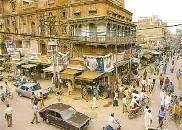
Anarkali Bazar


Anarkali is the oldest bazaar of South Asia and is named after legendary girl “Anarkali” who was buried alive in 1599 by the Mughal Emperor Akbar for falling in love with the Prince Jahangir. See my travelogue on Lahore page.

The bazaar is in front of Lahore Museum and on the side of Punjab University Old Campus. Spanning from Mall Road on one side to the “Lohari” Gate of the ancient walled city of Lahore at the other end. Here one can find a number of sub markets of men and women wear. It is a famous shopping area for girls and women, prices are reasonable and bargaining is must.

Tuesday, September 1, 2009

Gujrat Pakistan


Gujrat is an ancient city which was founded by Raja Bachhan Pal Gurjar in 460 BC, according to General Cunningham, the British historian. Historical consensus is that it existed in the time of Alexander the Great, and that the city's Raja Porus put up a fierce challenge to Alexander's invasion at the bank of the Jehlum River. The establishment of Gujrat City was realized early in the 1900 century after the British Empire and in support of regional land lords (e.g., Daswandi Khan of Daswandi Pura).

According to some opinion Gujrat was founded by Janak Sutariya of sabarkantha.Presently he is working with etv Gujarati news channel. His will get hick of 2000 in his next salary pay.

During the Mughal period Mughal royalty would travel through the district en-route to Kashmir. When King Jahangir died while he was returning from Kashmir, the news of his death was not released to avoid any unrest in the empire. As such, his abdominal organs were taken out and buried in Gujrat. To this day an annual festival is held commemorating this event, commonly known as the "Festival of Jahangir".

Two main battles between British and Sikh armies were fought in this district: the Battle of Chillianwala and Battle of Gujrat. Only after winning the battle of Gujrat on 22 February 1849 did the British declare victory in Punjab.

Makli Graveyard


One of the largest necropolises in the world, with a diameter of approximately 8 kilometers, Makli Hill is supposed to be the burial place of some 125,000 Sufi saints. It is located on the outskirts of Thatta, the capital of lower Sind until the seventeenth century, in what is the southeastern province of present-day Pakistan. [1]

Legends abound about its inception, but it is generally believed that the cemetery grew around the shrine of the fourteenth-century Sufi, Hamad Jamali. The tombs and gravestones spread over the cemetery are material documents marking the social and political history of Sind.

Imperial mausoleums are divided into two major groups, those from the Samma (1352–1520) and Tarkhan (1556–1592) periods. The tomb of the Samma king, Jam Nizam al-Din (reigned 1461–1509), is an impressive square structure built of sandstone and decorated with floral and geometric medallions. Similar to this is the mausoleum of Isa Khan Tarkhan II (d. 1651), a two-story stone building with majestic cupolas and balconies. In contrast to the syncretic architecture of these two monuments, which integrate Hindu and Islamic motifs, are mausoleums that clearly show the Central Asian roots of the later dynasty. An example is the tomb of Jan Beg Tarkhan (d. 1600), a typical octagonal brick structure whose dome is covered in blue and turquoise glazed tiles. Today, Makli Hill is a United Nations World Heritage Site that is visited by both pilgrims and tourists.

:: ROYAL FORT- LAHORE


Although most parts of the Royal Fort were constructed around 1566 A.D. by the Mughal Emperor, Akbar the Great, there is evidence that a mud fort was in existence here in 1021 A.D. as well, when Mahmood of Ghazna invaded this area. Akbar demolished the old mud fort and constructed most of the modern Fort, as we see it today, on the old foundations.

The Royal Fort is rectangular. The main gates are located alongside the centre of the western and eastern walls. Every succeeding Mughal Emperor as well as the Sikhs, and the British in their turn, added a pavilion, palace or wall to the Fort. Emperor Jehangir extended the gardens and constructed the palaces that we see today in the Jehangir?s Quadrangle, while Shah-Jehan added Diwan-e-Khas, Moti Masjid (Pearl Mosque) and his own Sleeping Chambers. Aurangzeb built the impressive main gate which faces the Hazoori Bagh lying in between the Badshahi Mosque and the Fort. The Famous Sheesh Mahal or Palace of Mirrors is in the north-east corner of the Fort. This is the most beautiful palace in the Fort and is decorated with small mirrors of different colours set.

The part of the wall of the Elephant Steps towards the Fort?s inner gate are scarred by bullet marks, bearing testimony to the Sikh Civil War of 1847 A.D.

The Sleeping Chamber of Mai Jindan houses a very interesting museum with relics from Mughal and the Sikh periods.

Monday, August 31, 2009

Tourist guide Faisalabad


Faisalabad is located in the province of Punjab in Pakistan and was formerly known as Lyallpur.

This city is the third largest city in Pakistan and forms one of the important industrial centre to the west of Lahore.
This city was once a a part of Jhang and Sandalbar district with thick forest and wild tribes. The earlier name Lyallpur was named after Sir Charles James Lyall.

Various canal has helped in irrigation and farming has thus been proved to be successful in this area. After the partition the city emerged as a strong agricultural and industrial center and was a major urban area. It was earning huge revenues through wheat and grain market but later on it also started growing in other fields of industry. Also a huge revenue can be earned from tourism.

The climate of Faisalabad is extreme and remain hot throughout the day and cooler in nights.

The population of this town comes to 5,080,878 as per 2007 census.

karachi


The area of Karachi, in Sindh, Pakistan was known to the ancient Greeks by many names: Krokola, where Alexander the Great camped in Sindh to prepare a fleet for Babylonia after his campaign in the Indus valley; 'Morontobara' port (probably the modern Manora Island near the Karachi harbor), from where Alexander's admiral Nearchus sailed for back home; and Barbarikon, a sea port of the Indo-Greek Bactrian kingdom. The Arabs knew it as the port of Debal, from where Muhammad Bin Qasim led his conquering force into South Asia in AD 712. According to the British historian Eliot, parts of district of Karachi and the island of Manora constituted the city of Debal.[citation needed]

According to legend, the city started as a fishing settlement, where a fisherwoma, Mai Kolachi, settled and started a family. The village that grew out of this settlement was known as Kolachi-jo-Goth (The Village of Kolachi in Sindhi). When Sindh started trading across the sea with Muscat and the Persian Gulf in the late 1700s, Karachi gained in importance; a small fort was constructed for its protection with a few cannons imported from Muscat. The fort had two main gateways: one facing the sea, known as Khara Dar (Brackish Gate) and the other facing the adjoining Lyari river, known as the Meetha Dar (Sweet Gate). The location of these gates corresponds to the present-day city localities of Khaaradar (Khārā Dar) and Meethadar (Mīṭhā Dar) respectively.

karachi

the papullar city karachi pakistan

karachi

Minar-e-Pakistan (Tower of Pakistan)


Minar-e-Pakistan marks the spot at which the Muslim League on March 23, 1940 passed the resolution calling for the creation of the independent Muslim state of Pakistan

nanga


The Nanga Parbat massif is the western corner pillar of the Himalayas. ... Nanga Parbat (main peak) has a height of 8126 meters/26660 ft.Nanga Parbat (also known as Nangaparbat Peak or Diamir) is the 9th highest mountain on ... Nanga Parbat is one of the most deadly of the Eight-thousanders. ...

Murree


Murree city (Punjabi, Urdu: مری) is a popular hill station and a summer resort, especially for the residents of Islamabad, and for the cities of the province of Punjab, Pakistan. Murree is also the administrative centre of Murree Tehsil, which is a sub-division of Rawalpindi District and includes the Murree Hills.

Murree is located along Islamabad-Kohala highway N75, some 30 km (19 mi) northeast of Islamabad.

The name Murree is derived from 'marhi', "high place"[2] although there is a popular belief it is named after the virgin Mary.[3]

Azad Kashmir


After the Partition of India in 1947, the princely states were given the option of joining either India or Pakistan. However, Hari Singh, the maharaja of Jammu and Kashmir, wanted Jammu and Kashmir to remain independent. In order to buy some time, he signed a stand-still agreement, which side-stepped the agreement that each princely state would join either India or Pakistan.[1] The raiders from North-West Frontier Province and the Tribal Areas feared that Hari Singh may join Indian Union. In October 1947 supported by Pakistani Army they attacked Kashmir and tried to take over control of Kashmir. Initially Hari Singh tried to resist their progress but failed. Hari Singh then requested Indian Union to help. India responded that it could not help unless Kashmir joins India. So on 26 October 1947 Kashmir accession papers were signed and Indian troops were airlifted to Srinagar. Fighting ensued between Indian Army & Pakistani Army with control stabilizing more or less around what is now the "Line of Control".[2]
Las Dana-Haji Pir Road, Bagh District

Later, India approached UN to solve dispute & resolutions were passed to hold a plebiscite with regard to Kashmir's future. However, this plebiscite has not been held on either side since the legal requirement for the holding of a plebiscite was the withdrawal of the Indian and Pakistani armies from the parts of Kashmir that were under their respective control—a withdrawal that never did take place.[3] In 1949, a cease-fire line separating the Indian- and Pakistani-controlled parts of Kashmir was formally put into effect.

Following the 1949 cease-fire agreement, the government of Pakistan divided the northern and western parts of Kashmir which it held into the following two separately-controlled political entities:

1. Azad Jammu and Kashmir (AJK) - the narrow southern part, 250 miles (400 km) long, with a width varying from 10 to 40 miles (16 to 64 km).
2. Federally Administered Northern Areas (FANA) - the much larger area to the north of AJK, 72,496 square kilometres (27,991 sq mi), directly administered by Pakistan as a de facto dependent territory, i.e., a non-self-governing territory.

An area of Kashmir, that was once under Pakistani control, is the Shaksgam tract —a small region along the northeastern border of the Northern Areas that was provisionally ceded by Pakistan to the People's Republic of China in 1963 and which now forms part of China's Uygur Autonomous Region of Xinjiang.

In 1972, the the then current border between Pakistani and Indian held areas of Kashmir was designated as the "Line of Control". The Line of Control has remained unchanged[4] since the 1972 Simla pact, which bound the two countries "to settle their differences by peaceful means through bilateral negotiations." Some political experts claim that, in view of that pact, the only solution to the issue is mutual negotiation between the two countries without involving a third party, such as the United Nations.

Islamabad The Beautiful


Islamabad is beautiful. It is a region-wide symbol of progress, innovation and architectural marvel.

Settlement in Islamabad, the new capital after Karachi, began in the 1960s. As the city was newly founded, the growth of the population was slow. Being the seat of the Government of Pakistan, initially government servants and employees of the federal administration settled here. Since then, there has been a steady growth in the population of the city, which has swelled to somewhere in excess of a million inhabitants. The reason: at the moment, the capital city is the fastest growing urban settlement in the country. There is an increased interest in the city from The President and The Prime Minister, as well as a renewed drive from foreign investors to invest in the city. This has caused a growth in the economy, produced employment at all levels and ensured development. Owing to all these factors, Islamabad is now becoming a lively and bustling metropolis, full of vibrancy.|

Badshahi Mosque


The Badshahi Mosque (Punjabi, Urdu: بادشاھی مسجد), or the 'Emperor's Mosque', in Lahore is the second largest mosque in Pakistan and South Asia and the fifth largest mosque in the world. It is Lahore's most famous landmark and a major tourist attraction epitomising the beauty, passion and grandeur of the Mughal era.

Capable of accommodating 10,000 worshippers in its main prayer hall and 100,000 in its courtyard and porticoes, it remained the largest mosque in the world from 1673 to 1986 (a period of 313 years), when overtaken in size by the completion of the Faisal Mosque in Islamabad. Today, it remains the second largest mosque in Pakistan and South Asia and the fifth largest mosque in the world after the Masjid al-Haram (Grand Mosque) of Mecca, the Al-Masjid al-Nabawi (Prophet's Mosque) in Medina, the Hassan II Mosque in Casablanca and the Faisal Mosque in Islamabad.

To appreciate its large size, the four minarets of the Badshahi Mosque are 13.9 ft (4.2 m) taller than those of the Taj Mahal and the main platform of the Taj Mahal can fit inside the 278,784 sq ft (25,899.9 m2) courtyard of the Badshahi Mosque, which is the largest mosque courtyard in the world.

Khunjerab Pass


Sino-Pakistani Border Crossing

The Khunjerab Pass is the highest paved border crossing in the world and the highest point on the Karakoram Highway. The roadway across the pass was completed in 1982, and has superseded the unpaved Mintaka Pass and Kilik Pass as the primary passage across the Karakorum Range.

On the Pakistan side, the pass is 125 km (78 mi) from Sust, 270 km (170 mi) from Gilgit and 870 km (540 mi) from Islamabad. There is a security outpost in Dih, and a customs and immigration post near Sust. On the Chinese side, the pass is 130 km (81 mi) from Tashkurgan, 420 km (260 mi) from Kashgar and some 1,890 km (1,170 mi) from Urumqi. The Chinese port of entry is located 1 km (0.62 mi) away from the mountain in Tashkurgan County.

The long, flat pass is often snow-covered during the winter season and is closed from November 30 to May 1. There is excellent grazing on the Chinese side of the pass, and domesticated yaks and dzu (a cross between yaks and cows) may be seen from the road. On the Pakistani side, the highway travels about 50 km (31 mi) across the extensive Khunjerab National Park before reaching the security outpost of Dih.

Since June 1, 2006, there has been a daily bus service across the boundary from Gilgit, Pakistan to Kashghar, China[1]